Schools
De Anza Students Help Coyotes Cross the Road
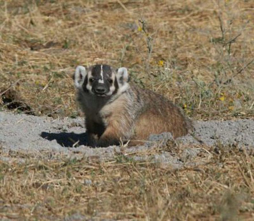
Student researchers document 26 mammal species crossing over or under Hwy. 101. Using remote cameras and other tracking techniques, the students developed a guide on how to foster safe passage between wildlife corridors in the valley.
The recent publication on Coyote Valley by environmental studies department is more than a list of recommendations and findings; it is a guide for the preservation of both the wild variety of birds and animals, and their habitat in the valley.
Safe Passage for Coyote Valley: A Wildlife Linkage for the Highway 101 Corridor, and the present undeveloped state of the valley, would not have been possible were it not for De Anza students physically in the valley collecting data. Students worked with trained animal trackers to identify where the animals were crossing the highway and which animals they were. The students were left to figure out how the animals crossed on their own.
If the name “Safe Passage” sounds familiar, it’s because the publication was modeled off the Southern Rockies ecosystem project, Safe Passage: A Users Guide to Developing Effective Highway Crossings for Carnivores and Other Wildlife, written by Bill Ruediger and Monique di Giorgio.
Find out what's happening in Campbellwith free, real-time updates from Patch.
“Different animals use different size culverts,” said Laura Coatney, a De Anza student in the environmental studies program, and one of many student researchers for the publication. “We would look for signs of animals, scat or tracks, and focused around the creeks.”
The students installed remote cameras to track the animals over the next four years. By tracking where the animals that used the drainage based culverts went, the authors of the publication could better recommend where an animal designed culvert should be placed. Coatney said that while small animals such as the valley’s coyote and bobcat can use small culverts, larger animals such as the tule elk and black-tailed deer will need specially designed crossing points.
Find out what's happening in Campbellwith free, real-time updates from Patch.
As the entire highway’s culverts and underpasses were designed for water drainage, and not animal crossing, construction is a certainty.
“A culvert is a passage under the road for animals,” publication co-author and environmental studies instructor Julie Philips said. “Currently they are storm drains, with no thought put towards to animal travel.” Philips added that because culverts are not held to the same building standards as human or vehicle crossing points, the costs should be limited.
In all, De Anza students and staff have documented 26 mammal species using at least six culverts/overpasses/underpasses along the highway in what the publication calls “a biodiversity hotspot.” Not only were the animal species identified, but by placing the cameras in opposition to each other, the student researchers could identify and track individual animals over the course of the study.
According to Philips, this level of research has never been done by community college students. “I don’t think this has ever happened before,” Philips said.
It all began in 2006 when the Committee for Green Foothills attempted to block the latest effort to develop Coyote Valley. Under what would become known to the City of San Jose as the Coyote Valley Specific Plan, Coyote Valley would be urbanized into a city of 60,000 to 80,000 people and was set to move forward despite objections about the environmental impact study which said the valley was no longer a “viable corridor.”
Simply put, a "viable corridor” is a place where animals travel between environments or habitats, like an airport you have to make a connection at to arrive at your final destination. In this case, as a result of its low impact agricultural environment, Coyote Valley has remained a corridor for north-south and east-west animal crossing, playing a vital role in animal migration, movement and dispersal.
Philips said animals will travel both regularly and seasonally from the east hills, the Mount Hamilton region of the Diablo Range, through Coyote Creek and to the surrounding west hills, Santa Teresa and the Santa Cruz Mountains. Their movement is hindered, however, by Hwy. 101 which cuts straight down the center of the valley.
“[The plan] acknowledged animals were there but said 101 was a barrier and [development] would have no impact,” Philips said. While Philips agrees that Hwy. 101 is a barrier, she disagrees with the plan’s assessment that the valley was no longer viable as a corridor and believed the valley still facilitated animal movement.
In response to the analysis, Philips, her son (who is also an instructor at De Anza) and their students hit the creek bed with trained trackers and motion cameras conducting what Philips said is still the largest study on wildlife movement in the corridor. Their findings were published in the 2008 annual report by the Kirsch Center and, soon after, the city withdrew the plans to develop Coyote Valley.
The findings were shocking, not only by the number of animals found to still migrate over and under the highway but also with how nearly fraudulent the original impact study was done, the report said.
“[The] researchers didn’t get out of their cars,” said Philips. “They literally did not get out of their cars … The people who were doing the actual plan were very earnest about getting this done.”
Philips’ complaints were joined by Brian Schmidt, former Santa Clara County Legislative Advocate to the committee and now part of the Santa Clara Valley water board, who wrote in the spring printing of Green Footnotes, “the environmental analysis [of Coyote Valley] was even worse, with literally drive-by biological analysis, easily refuted by student volunteers at De Anza College, and other components done so poorly that it caught the attention of California’s Attorney General.”
So we know coyotes cross the highway, but why? Why does the coyote cross the road?
Well, elk cross the highway to get access to better habitat, while predators, like the coyote, cross in search of prey. The most obvious concern with animal crossing is the negative impact on the human population, and there is significant data to support safe passage is both safer for animals and people.
One of the most striking series of images taken during the project, said Philips, was when a mountain lion was identified using a path mere minutes before a human jogger. By providing culverts that attract mountain lions with open line of sight, rather than repel them as the current storm drains do, the possibility of animal attacks drop. Culverts will also minimize vehicle-animal collisions with large animals, which can be both destructive and dangerous.
According to the publication, a “considerable” tule elk herd is present on the east side of Hwy. 101 and does not currently use the existing crossing structures to migrate. Instead, the elk cross over the highway; endangering themselves and the drivers who have the potential to collide with these 750-pound animals.
If the publication’s recommendations are implemented the authors expect California to see a drop in elk-vehicle collisions similar to what Arizona experienced; “nearly a 99 percent decrease in elk related accidents” was recorded after the installation of underpasses and directional fencing.
However, implantation of the recommendations is the key, as this publication has no binding power and De Anza was not contracted by any agency to perform this research. Although, as a result of California Assembly Bill 2785 which mandated the California Department of Fish and Game to identify wildlife corridors, future action may be taken utilizing De Anza’s student and faculty research.
“While the county allowed the study to take place, they gave no power,” Philips said. “Most of the land is privately owned. The county will not take private land. They can buy the land or hold it in a trust, but the Department of Fish and Game is now mandated to acknowledge the land.”
“The plan has teeth,” as Coatney put it, “and they’re sharp. But they’re baby teeth.”
More information on De Anza’s corridor project can be found at http://www.deanza.edu/es/wildlifecorrproj/ or by calling the Kirsch Center at 408-864-8316. The Kirsch Center is also open to the public and is located adjacent to De Anza's south entrance.
Are you Patched in? Get the FREE Patch newsletter each morning. Register here.
Into social media? So are we. Join us on facebook, twitter or instagr.am (@campbell_patch).